Survey reviews are a critical step in commercial real estate (CRE) transactions. They ensure that property boundaries and easements align with legal records, helping to avoid costly issues like boundary disputes, encroachments, or development restrictions. Without a detailed survey, buyers may face unexpected liabilities, such as unrecorded easements or access issues, that can disrupt property use and value.
Key Takeaways:
- ALTA Surveys: These surveys integrate title data, field observations, and mapping to identify easements and boundary details.
- Schedule B-II Exceptions: Surveyors must reconcile recorded easements with on-site conditions to ensure accurate documentation.
- 2026 ALTA Standards: Updates include new requirements like digital file formats and a summary table for encroachments (Table A Item 20).
- Easement Challenges: Overlapping easements can affect property value, access, and development plans.
- Collaborative Efforts: Surveyors, title companies, and legal counsel must work together to address discrepancies and negotiate solutions.
Why It Matters:
Easements impact property rights, access, and development potential. By reviewing surveys early, buyers can address risks, negotiate terms, and secure better title insurance coverage. Proper documentation and stakeholder collaboration are essential for smooth transactions and long-term property management.
What Should Land Surveyors Do With Easements On A Land Title Survey?
sbb-itb-df8a938
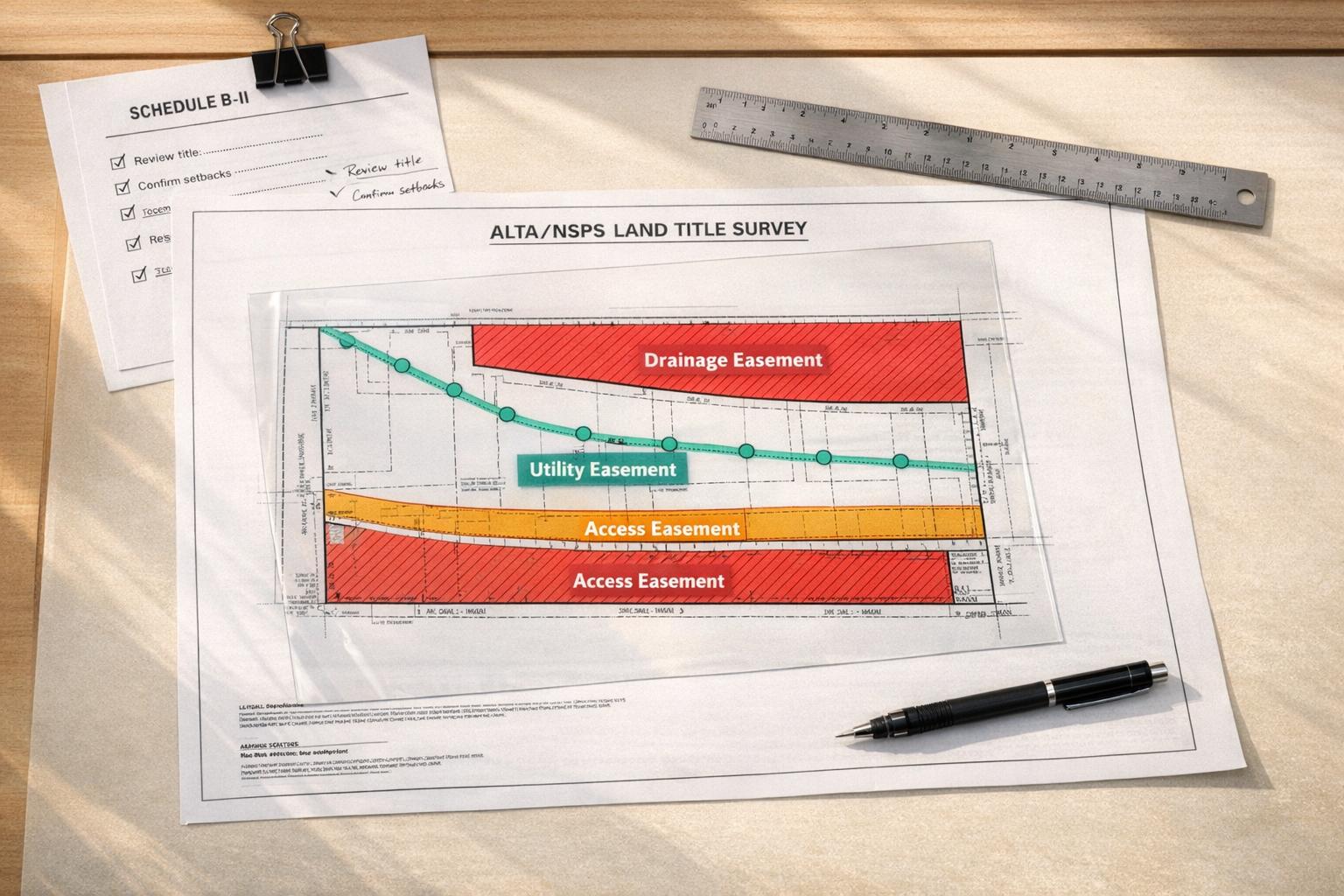
Key Components of an ALTA/NSPS Survey for Easements
An ALTA/NSPS survey brings together title data, field observations, and detailed mapping to accurately identify easements. The process begins with the surveyor reviewing Schedule B-II of the title commitment, which outlines all recorded easements, restrictions, and encumbrances impacting the property. Fieldwork then documents utility markings, access points, and rights-of-way. Finally, the surveyor creates a map or plat that integrates the recorded easements with physical features observed on-site. This comprehensive approach ensures a thorough review process aimed at reducing risks.
Understanding Schedule B-II Exceptions
Schedule B-II is a critical section in the title commitment where title companies list recorded easements and other encumbrances. Surveyors must address each exception by either illustrating it on the survey plat or explaining why it cannot be located. If an easement is recorded but not visible during fieldwork, the surveyor must notify the title company and include it on the map unless there is documented proof of its termination. The 2026 standards clarify that easements can end through legal mechanisms like abandonment or merger, and surveyors are responsible for reporting these terminations based on title evidence. This reconciliation helps title insurers remove standard exceptions from coverage. Beyond Schedule B-II, additional optional requirements provide further details about specific easements.
Table A Items Relevant to Easements
Table A items complement recorded data by addressing on-site factors, such as underground utilities, with precision. These optional survey requirements allow clients to tailor the survey to their needs. For instance:
- Item 11: Documents underground utilities and visible utility easements.
- Item 19: Maps offsite easements, such as shared access or utility easements, with the same level of detail as the primary parcel.
- Item 20: Introduced in the 2026 standards, this item includes a summary table highlighting potential encroachments, making it easier for stakeholders to spot and address issues quickly.
Aaron Whyte, an attorney at Gould & Ratner, highlighted the significance of these updates:
"give real estate owners, developers, and lenders opportunities to leverage 2026 ALTA surveys as a more effective risk-management tool." [5]
For complex transactions, requesting Item 20 upfront can streamline the review process and identify potential challenges that may need resolution before closing.
Surveyor Plottings and Easement Mapping
After gathering recorded and on-site data, the surveyor produces a final map to verify and reconcile easement details. According to Section 6 of the 2026 standards, surveyors must depict all easements, including "blanket" easements with no defined location, and compare recorded dimensions with field measurements. This precise mapping helps title insurers confirm easement details and reduces the likelihood of future boundary disputes. Errors in mapping can disrupt transactions, as John T. Cagigas from Taft Stettinius & Hollister explained:
"should help reduce underwriting uncertainty", it can also "identify further potential encumbrances that should be closely examined." [6]
Given the extensive research and mapping involved, ALTA surveys are typically 50% to 200% more expensive than standard boundary surveys. However, this investment often prevents costly post-closing problems. [7]
How to Review Easements: A Step-by-Step Process

Step-by-Step Process for Reviewing CRE Easements on ALTA Surveys
Once the ALTA/NSPS survey is complete, it’s time to dive into the review process. A clear and methodical approach can help you identify discrepancies, understand restrictions, and avoid potential issues that might affect a transaction or the property’s value. Using the survey as your foundation, follow these steps to ensure the easement data is accurate and complete.
Matching Title Commitments with Survey Data
Start by comparing the most recent title commitment with the survey. Every easement listed in Schedule B-II should appear on the survey plat, with accurate dimensions and locations [4].
Vincent Macauda, National Practice Lead for ALTA Surveys and Zoning at CBRE, underscores the importance of this process:
"The ALTA Survey is the survey of choice for commercial transactions that involve higher dollar and policy amounts." [4]
Carefully check that the legal description in the title commitment matches the description on the survey. Look for discrepancies, overlaps, or incomplete closures [4]. If the survey shows an easement in a different spot than recorded, or if an easement appears on the survey but not in the title commitment, flag the issue and address it before closing. These discrepancies can impact the title policy, as the title company will need to adjust exceptions based on the survey findings. This could include unrecorded easements or encroachments [4].
To add an extra layer of security, request specific ALTA endorsements. For example, ALTA 25-06 ensures the land described in the title commitment matches the land on the survey, while ALTA 17-06 confirms vehicular and pedestrian access to a public street via an insured easement [4]. These endorsements are particularly helpful when easement locations or access rights are critical to the deal.
Once you’ve flagged any inconsistencies, shift your focus to utility and access easements.
Reviewing Utility and Access Easements
Next, review both recorded easements and on-site utility evidence. Utility and access easements play a key role in how the property can be used or developed. According to current ALTA standards, surveyors must include observed utilities on the survey as part of their fieldwork [4]. This is where unrecorded easements – like utility lines or access paths that aren’t in public records – often come to light [8].
Check if utility easements restrict permanent structures or impact water flow [2]. Shared access areas, such as driveways or utility corridors, require extra attention. Confirm who is responsible for maintenance and ensure priority of access is clearly defined [2]. The ALTA survey provides a detailed map of the property’s existing improvements, utilities, and other significant observations within the insured estate [1].
If conflicts arise between easements and development plans, negotiate adjustments with the easement holder [2]. For planned developments, consider requesting Table A Item 11(b) to hire a private utility location service. This helps pinpoint underground utilities and identify potential conflicts before construction begins [4]. For shared access, formal maintenance agreements can help avoid disputes by clearly outlining repair responsibilities [2].
Identifying Encroachments and Boundary Conflicts
After reviewing recorded and utility easements, examine the survey for physical encroachments or boundary misalignments. These issues can complicate property use or even derail deals. The ALTA survey is essential for spotting encroachments like buildings, fences, or parking lots that cross boundary or easement lines [4]. Common problems include gaps and gores (unintended strips of land between parcels), overlaps with neighboring properties, and improvements that violate setback requirements or encroach into utility easements [4][2].
Wendy S. Gibbons, Senior Vice President and Deputy Chief Underwriting Counsel at Old Republic National Title Insurance Company, explains the impact:
"If the survey reveals encroachments, encumbrances, violations of setback lines, boundary line issues, or other adverse circumstances, the same will be ‘read’ into the policy by the title company and those matters will appear as exceptions." [4]
Verify on-site markers for underground utilities, as they can indicate unrecorded easements [4]. If the survey is outdated, ask the seller for a "no-change" affidavit to confirm no significant changes have occurred [4].
For buildings that extend into easements, contact the easement holder to request an abandonment of the easement or a recorded consent to encroach. This can satisfy title company requirements [4]. Alternatively, consider title endorsements like ALTA 28-06, which offers protection against the forced removal of structures encroaching into easements [4]. Developers may also resolve overlapping or conflicting easements by creating buffer zones or adjusting project designs to avoid restricted areas [2].
How Easements Affect Development and Property Use
Easements play a critical role in shaping how properties can be developed and used. They define buildable areas and influence where structures can be placed. Understanding these restrictions early is essential to avoid setbacks like delays in development, permit denials, or financing issues. Here’s a closer look at how easements can impact development plans.
Checking for Setback Violations and Overlaps
Setback lines act as invisible boundaries that dictate where structures can be built on a property. These setbacks often range from 20–25 feet at the front, 5–10 feet on the sides, and 10–20 feet at the rear of a property [9]. Violating these boundaries can lead to permit denials for projects like room additions, garage extensions, or covered patios. Additionally, permanent structures cannot be placed in easement areas, meaning features like pools, patio extensions, storage sheds, pergolas, or retaining walls must be relocated elsewhere [9][2].
Logan Walter, a Realtor, offers this practical advice:
"If you want to add a pool, patio, or extension in Texas – study the survey BEFORE you buy" [9]
Overlapping easements, such as utility and drainage easements, can further complicate matters. These overlaps often restrict development, requiring that affected areas be used only for landscaping or open space [2]. According to Christopher Evans of South Texas Surveying, overlapping easements can create conflicts that delay projects and complicate property management [2].
In addition to setbacks, easement terms often influence access and utility placements, both of which are vital for a successful project.
Reviewing Property Access and Utility Placement
Access easements are key to determining whether a project is even feasible. For example, an easement granting only "ingress and egress" may not necessarily include the right to install utilities [10]. Ahead of Schedule Law highlights the potential risks:
"A poorly drafted easement could hobble an entire development. Counsel should always be consulted to avoid the crippling impact of a development held hostage" [10]
Financing can also become an issue if a property lacks clearly documented, perpetual access rights, as some lenders may refuse to approve loans under these circumstances [10].
When drafting or reviewing access easements, it’s crucial to include provisions for commercial vehicles, pedestrian access, and utility installations. This helps avoid operational delays and ensures the project stays on schedule [10]. For properties with overlapping utilities, formal maintenance agreements can clarify repair responsibilities and access priorities, reducing the risk of legal disputes and keeping operations running smoothly [2].
Working with Stakeholders to Resolve Easement Issues
Tackling easement issues demands collaboration between multiple professionals. Surveyors handle fieldwork to map out easements and utilities, ensuring everything is accurately documented [4][1]. Title companies assess risks tied to easements and decide whether to remove survey exceptions [4][3]. Legal counsel plays a key role by reviewing Schedule B-II exceptions, negotiating with title companies to address them, and preparing necessary documents like boundary line agreements [4][3]. Additionally, easement holders – often utility companies or neighboring property owners – may need to provide formal consent, abandon unused easements, or confirm that no physical lines are present [4].
Wendy S. Gibbons, Senior VP and Deputy Chief Underwriting Counsel at Old Republic National Title Insurance Company, highlights the importance of collaboration in these efforts:
"It is up to the insured to obtain a survey and correspondingly negotiate with the surveyor those items that should appear on the survey to benefit the surveyor’s client, the title insurer issuing the title policy, and the lender providing financing for the transaction." [4]
Sharing title information early is crucial to avoid delays during closing. Surveyors typically require the latest title commitment before beginning their work. Ordering ALTA surveys alongside zoning reports – ideally from the same consultant – can help maintain consistency and prevent conflicting data [4][1]. For easements or other non-fee simple interests, expanding the survey scope beyond standard requirements can address potential challenges [4]. Coordinating with all stakeholders ensures effective risk management and lays the groundwork for resolving ambiguities in easement documentation.
Clarifying Ambiguous Easements
Unclear easement language can create confusion about property rights and development limitations. When surveys uncover inconsistencies, title companies may issue curative documents for legal counsel to address [4]. For example, if a recorded easement exists but no physical infrastructure is visible, legal counsel should examine the full text of the easement and work with utility providers to confirm whether active lines are present. This verification may convince the title company to "insure over" the risk [4][3].
Consider a scenario where an easement specifies only "ingress and egress." Such language might not include the right to install utilities, potentially disrupting development plans. Resolving these ambiguities promptly allows for negotiations to modify or remove easements as needed.
Negotiating Easement Changes or Exception Removal
If a building encroaches on an easement, swift action is necessary. Work with easement holders to negotiate relocations, secure recorded consents, or apply ALTA endorsements like ALTA 28-06 to address risks [4]. For obsolete easements, pursue their formal release [2][4]. These steps follow the identification and clarification of easement issues, creating a logical progression in the resolution process.
Supporting existing survey data with affidavits can also be beneficial. In some cases, title companies might agree to remove standard survey exceptions without requiring a new survey, particularly for loan policies with liability amounts ranging from $10 million to $25 million – provided no recent construction has taken place [4].
The ALTA 28-06 endorsement offers protection against forced building removal due to easement maintenance. However, its coverage is generally limited to buildings and doesn’t extend to parking lots, fencing, or retaining walls [4]. For shared access or utility easements, formalizing maintenance agreements can help resolve potential conflicts [2].
Documenting and Tracking Easements for Future Reference
Keeping easement records well-organized is crucial to avoid delays during property transactions or refinancing. A system that ties the title commitment to the ALTA/NSPS survey can help identify issues like boundary discrepancies, unrecorded easements, or encroachments. Once easement details are confirmed and stakeholder concerns are resolved, documenting and updating these changes becomes essential for managing risks over time. By addressing easement issues and maintaining clear records, future transactions can proceed more smoothly.
Setting Up an Easement Documentation System
To establish a reliable system, start by organizing records based on Schedule B-II exceptions from title commitments. Create dedicated files for each recorded easement, covenant, or restriction. Include the complete text of title exception documents to ensure you capture any operational limitations.
Maintain a resolution log to track issues like easement releases, maintenance agreements, or boundary adjustments. For properties benefiting from tax abatements or TIF agreements, document ongoing obligations such as employment requirements or capital investment commitments to avoid financial penalties during ownership changes. Additionally, keep records of non-recorded restrictions, such as zoning compliance letters, certificates of occupancy, and landmark designations, as these may not appear in public title records.
Modern tools like Geographic Information Systems (GIS) and data analytics can enhance record-keeping by linking field data to historical documents. For example, in November 2024, a county planning department resolved access disputes by combining historical records with updated survey data using the DataCalculus platform. This approach helped surveyors identify outdated easement definitions and provided a clear, data-driven perspective to stakeholders, ensuring precise boundary demarcations.
Keeping Records Current
Once the initial documentation is organized, it’s important to keep it up to date. Make updates whenever easements are modified, relocated, or released. If an easement is no longer needed, ensure the legal release or updated plat is recorded in public records to maintain a clear chain of title. For refinancing or quick transactions, property owners can use a "no-change-since-the-date-of-the-last-survey" affidavit to rely on a previous survey, as long as no new improvements or encroachments have occurred. However, title companies typically require that the survey falls within the state’s statutory period for adverse possession [4].
To minimize confusion, attach visual plats to your records. Include both a metes and bounds legal description and a professional drawing to clearly define the easement’s width and location. For temporary easements, use a calendar or tracking system to ensure expired easements are updated or removed promptly. Properties with well-maintained easement records are more appealing to buyers and tenants, offering clarity on usage rights and fewer uncertainties [2].
Conclusion
Reviewing surveys for commercial real estate easements requires carefully matching the Schedule B-II exceptions from the title commitment with the ALTA/NSPS survey. This ensures all recorded easements are properly plotted and identified. Beyond public records, surveys uncover physical encumbrances such as unrecorded easements, utility markers, and encroachments, which can lead to title defects or liabilities [3][4]. Additionally, confirming both legal and physical access to public roads is essential. The survey must verify that the property isn’t landlocked and that access easements are sufficient for its intended use. These steps are key to addressing potential issues before finalizing a transaction.
Collaboration between surveyors, title professionals, and lenders is critical to resolving concerns early. By engaging these parties in advance, solutions such as boundary line agreements, easement releases, or specific title insurance endorsements like ALTA 28-06 can be implemented. Identifying risks upfront allows buyers to adjust pricing, negotiate indemnities, or revise deal terms, helping to avoid costly post-closing problems.
Before survey work begins, provide the latest title commitment and easement documents, as surveyors often require these to get started [4]. Selecting Table A Optional Items – like Item 11 for underground utilities or Item 18 for offsite easements – ensures the survey meets lender and project needs. For properties with no recent changes, a "no-change-since-the-date-of-the-last-survey" affidavit can reduce costs, provided the survey still falls within the state’s adverse possession timeframe, which typically ranges from 5 to 20 years [4][11].
Keeping well-organized easement records linked to the survey and title commitment protects the property’s value, attracts buyers, and reduces legal risks. Clear documentation provides transparency around usage rights and minimizes operational restrictions [2]. By following these best practices – from understanding Schedule B-II exceptions to maintaining systematic records – property owners can optimize development opportunities while reducing uncertainties in transactions. This proactive approach aligns with The Fractional Analyst’s focus on minimizing risks in commercial real estate deals.
FAQs
When do I need an ALTA/NSPS survey instead of a boundary survey?
An ALTA/NSPS survey provides a detailed breakdown of property boundaries, title matters, and location specifics. It’s essential for identifying potential issues like encroachments or easements and is often required to satisfy lender or title insurance requirements. This type of survey is particularly important in commercial real estate transactions, where having precise and thorough information can influence key decisions.
What should I do if the survey and Schedule B-II don’t match?
If the survey and Schedule B-II reveal inconsistencies, it’s crucial to examine those differences closely. Some issues might be addressed by obtaining an updated survey or adding endorsements, while others could stem from the property’s characteristics and may need deeper investigation. Resolving these matters thoroughly helps prevent potential roadblocks during the transaction.
Which Table A items matter most for easements on my deal?
When dealing with easements, certain survey details are critical. These include:
- Property boundaries: Clearly marked boundaries help define the exact limits of the property.
- Existing easements: Identifying these ensures you’re aware of any rights others might have over the property.
- Encroachments: Pinpointing any structures or features crossing property lines is essential.
These elements play a crucial role in verifying the existence and scope of easements, helping ensure accurate evaluations for your transaction.
Leave a Reply